The area is a Transformation Area under the Planning Document (PGT) for 2024, primarily designated for residential use and green spaces, with a maximum developable area of 22,700 square meters. The main objective of the transformation area, given its proximity to the South Milan Agricultural Park and the Parco delle Rogge, is to complete the Municipal Ecological Network by leveraging existing landscape elements.
For this reason, the protective guidelines of the Metropolitan Territorial Plan (PTM) must be respected by including within the area specific zones and interventions that are part of the broader system of the Municipal Ecological Network (REC). The goal is to ensure the permeability and continuity of the Parco delle Rogge and to enhance the natural features present.
During the design phase, particular attention must be paid to the preservation of existing natural elements, and suitable integration and mitigation interventions must be ensured. These interventions should apply to both settlements and planned mobility infrastructure, drawing on the reference models found in the “Catalogue of Landscape and Environmental Mitigation and Compensation Measures” and the “Handbook of Nature-Based Solutions (NBS).”
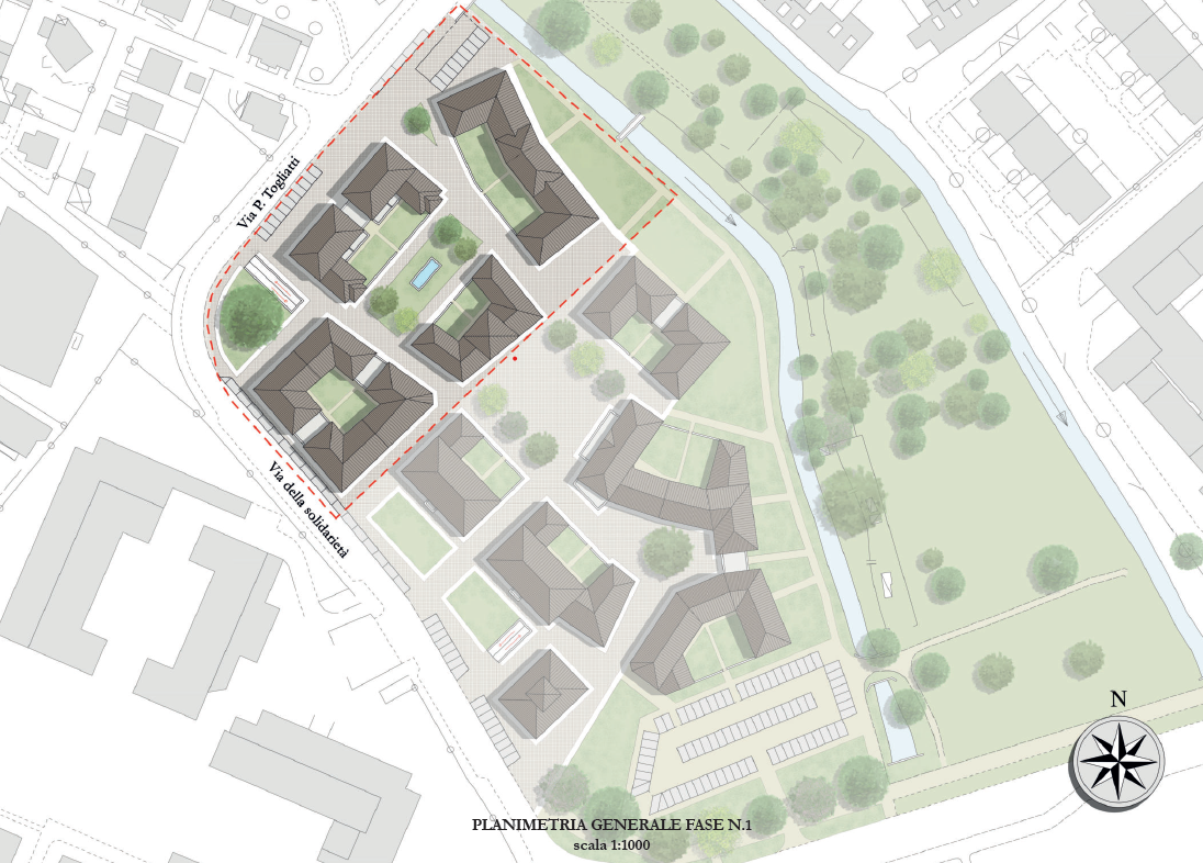
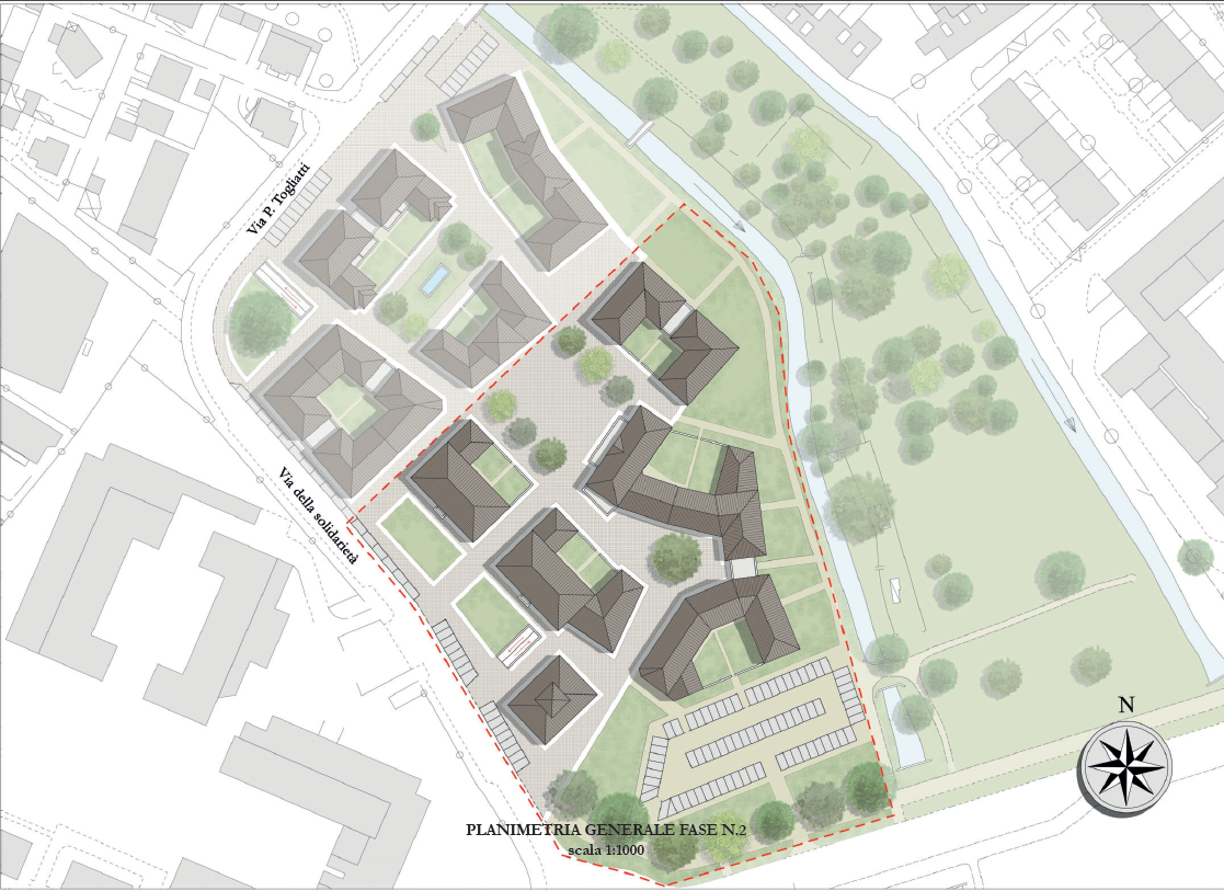
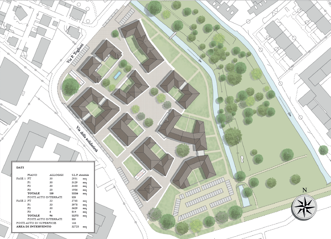
The Implementation Plan must reflect the urban, architectural, and relational composition typical of historic villages and town centers, as outlined in the “Urban and Architectural Study – Rozzano Vecchio Sports Field Area / Residential Area,” which the project proposal must refer to.
The Detailed Development Plan was approved on 24 June 2026.
Public Notice – Auction for the Sale of the Real Estate Complex: offers must be submitted by 12:00 p.m. on 12 October 2026.
Rozzano is an Italian municipality with 41,594 inhabitants, located in the Metropolitan City of Milan, in the Lombardy region, along the route connecting the regional capital Milan to Pavia. The municipal territory is crossed by the Southern Lambro River.
Rozzano is longitudinally crossed by the A50 Motorway (Milan Western Ring Road) and bordered to the west by the A7 Motorway ("Milan–Serravalle"). Within the municipal area, there are two exits on the Western Ring Road: exit no. 7 SS35 Pavia/Milan Ticinese and exit no. 7bis Rozzano Quinto de' Stampi/Milan Via dei Missaglia.
The metropolitan municipality is also crossed by the provincial road (formerly state road) 35 dei Giovi, which connects Milan to Genoa via the Giovi Pass.
The natural area within the municipal territory of Rozzano is part of the South Milan Agricultural Park (Parco Agricolo Sud Milano).
Public
25.000 m²
Offices, Retail and services, Residential, Tourism/hospitality
Nuovo progetto
Sales
The area is already urbanized, with existing networks for water, electricity, gas, sewage, fiber optics, and public lighting.
Currently, approximately 40% of the area is occupied by a football field with an adjacent disused service building, which is to be demolished, while the remaining part of the area—apart from a small public parking lot scheduled for removal—is unoccupied. Therefore, removals are limited.
The area is available and free from passive easements.
26/05/25
29/07/26